Enregistrez gratuitement cette image
en 800 pixels pour usage maquette
(click droit, Enregistrer l'image sous...)
|
|
Réf : T02662
Thème :
Terre vue de l'espace - Iles - Récifs (286 images)
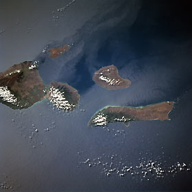
Titre : Lanai, Maui, and Molokai, Hawaiian Islands October 1998
Description : (La description de cette image n'existe qu'en anglais)
Lanai, Maui, and Molokai, Hawaiian Islands October 1998 The Hawaiian Islands of Maui, Kahoolawe, Lanai, and Molokai can be seen in this south-southwest-looking view. Maui (left center of the image) is the second youngest and second largest of the main Hawaiian Islands. Maui covers an area of 728 sq. miles (1886 sq. km). The island consists of two large volcanoes, West Maui (extinct) and East Maui, (Haleakala) which last erupted in 1790. Kahoolawe is the smallest of the four islands in the scene. It covers an area of 45 sq. miles (117 sq. km) and lies 10 miles (16 km) southwest of the southwestern Cape of Maui. Overgrazing and bombing by the military produced a red “Dust Bowl” in the center of the island. Lanai (near the center of the image), owned by the Dole Pineapple Company, is the remnant of a volcano that is over one million years old. Lanai covers an area of 141 sq. miles (365 sq. km) and is 18 miles (29 km) long and 13 miles (21 km) wide. Molokai (situated north of Lanai) covers an area of 261 sq. miles (676 sq. km) and is 38 miles (61 km) long and only 10 miles (16 km) wide, with the west end being very dry.
|
|

